Within Georgia State University Library’s digital collections can be found a series of approximately 100 photographs depicting downtown Atlanta streets in 1927, focusing mainly on the area just south of GSU’s present-day downtown campus. These images were scanned from glass plate negatives owned by the Special Collections of the Atlanta-Fulton Public Library System, which were loaned to GSU Library so that they could be digitized and shared with a wider audience. Of particular interest are images of city streets and storefronts at street level before many were covered over to make way for the “twin viaducts” project of 1927-1929, the city project that elevated the street levels of Central Avenue and Pryor Street (the viaducts) running north to south as well as Alabama and Wall Streets (the laterals) running east to west. This project quite literally entombed the original ground-level streets and storefronts below to become what we now know as Underground Atlanta.
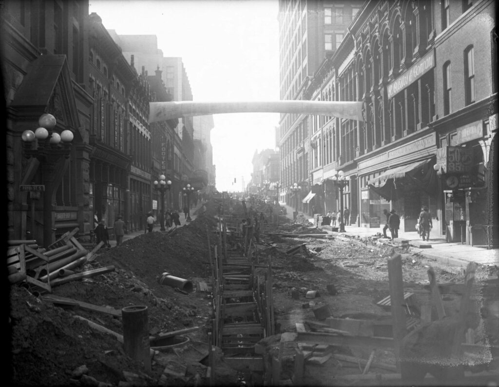
Figure 1. Alabama Street, looking west from Pryor Street, in 1927 (in what is now Underground Atlanta) as preparations are being made for the covering. Atlanta-Fulton Public Library System Glass Plate Negative AFPL005x_006, GSU Library Special Collections & Archives
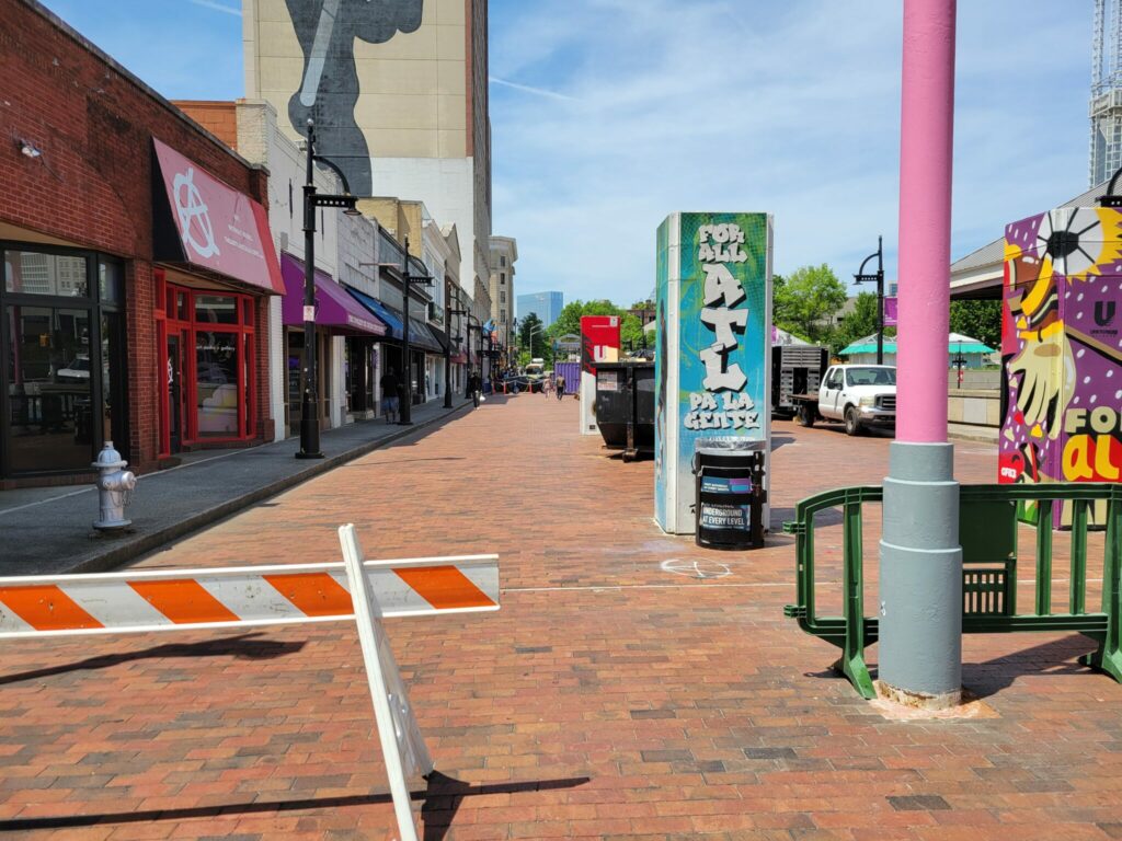
Figure 2. (Upper) Alabama Street today, looking west from Pryor Street in 2024. Photo by the author.
Thanks to this unique collection of images, we can return to downtown Atlanta before the construction of these viaducts and elevated streets. In Spring 2016, a group of students working in the GSU Library under the direction of then Maps & GIS Librarian Joe Hurley conducted a project involving these digitized glass-plate negatives by which they would revisit Atlanta in 1927 just before the viaduct project of 1927-1929. The students first set out to geo-tag these images and then “stitch” them together in order to create panoramic “streetscapes” of entire city blocks or portions of blocks of these downtown Atlanta streets soon to be covered and largely abandoned.
These photographs provide a rare glimpse of Atlanta life at that period from ground level, including advertising signs for freak shows and NuGrape soda, restaurant menus and prices, and storefronts of numerous businesses: barbershops and baths, shoe repair shops, drug stores, a billiards and chili parlor, and many others. They depict Black and White Atlantans, including working class laborers, shopkeepers, and businessmen, going about their daily lives. They may also show an area of downtown that was somewhat in decline. Reports in The City Builder at the time indicate the area had become stagnant, not helped by the constant traffic congestion caused by trains passing through this area, with some businesses declining in sales and some buildings allowed to deteriorate.1
These images portray a city readying to move on and up to something new, with many businesses advertising moving sales and posting their new addresses on shop windows. They further document the preparation work and surveying happening at the street level as the city readied for this major construction project: streets would need to be raised in some areas and lowered in others in order to accommodate motor traffic underneath. Up and down Alabama Street, modifications and upgrades to underground electric cabling, gas mains, sewers and other improvements were required before construction could begin.
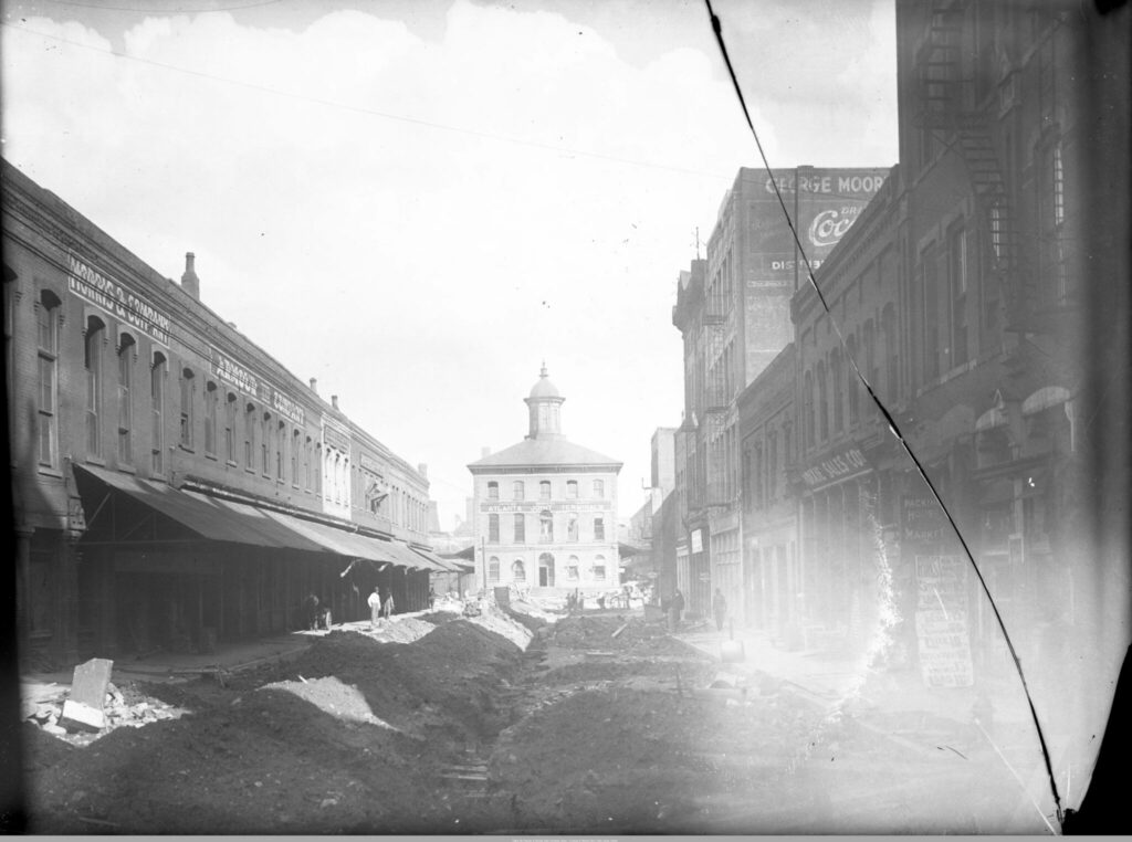
Figure 3. Preparing Alabama Street for the covering in 1927. Looking east toward to the future Central Avenue Viaduct and Georgia Freight Depot, whose main level still stands today. Atlanta-Fulton Public Library System Glass Plate Negative AFPL002x_014, GSU Library Special Collections & Archives
Similarly, concerns regarding drainage and grading would need to be addressed. Alabama Street would need to be elevated where it met Pryor Street, making it level with Whitehall Street (now Peachtree).2 In other sections, the brick paved streets would be torn up, lowered several feet, and then repaved in order to maintain clearance below. The plan was for storefronts and businesses to move their main entrances to the platform story above, leaving the story below as a service entrance for deliveries with ample height for delivery trucks. At the same time, extensive excavation work was required to lower and relay the tracks for rail clearance beneath the viaducts.3
The map below indicates the location of the street images photographed in 1927 as crews began to prepare the area for the viaduct construction. All of the original glass negatives and panoramic “streetscapes” created by GSU students under the direction of Joe Hurley can now be accessed through GSU Library’s Digital Collections.
Figure 4. This reference map is taken from the 1911 Sanborn maps. The street names here remain the same, except for Hunter Street, which is now Martin Luther King Jr. Drive.
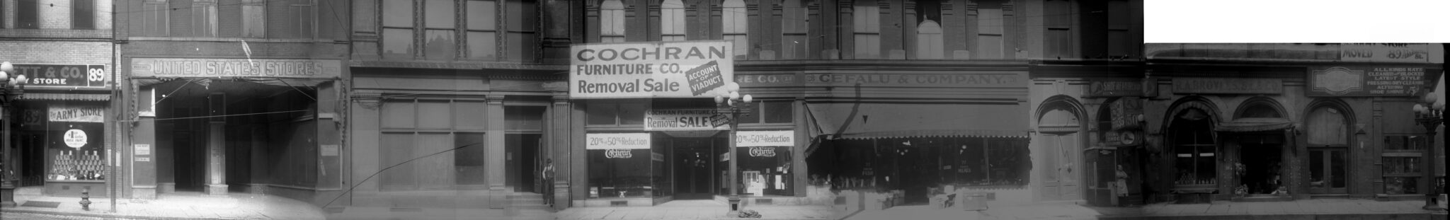
United States Store, 85 Alabama Street SW, Atlanta. Duckett & Co. Army Store. 89 Alabama Street SW. Vacant building, 83 Alabama Street SW. Cochran Furniture Company, 79 Alabama Street SW. Sign above storefront reads: “Cochran Furniture Co. Removal Sale, Account of Viaduct.” Cefalu and Company Grocers, 77 Alabama Street SW. “Hotel” is painted on the adjacent door. Asian Bearo Shoe Repair, 75 Alabama St., SW. R.A. Broyles, Sr. and Company grocery store, 73 Alabama Street SW. Signs to the right at 71 Alabama St., SW read: “Pay Day – Everybody Likes It!”; “All Kinds of Hats Cleaned and Blocked, Latest Style, Pressing, Dry Cleaning, Altering, Shoe Shine”; and “The Army Store Duckett & Co. Moved 89 Alabama St.”
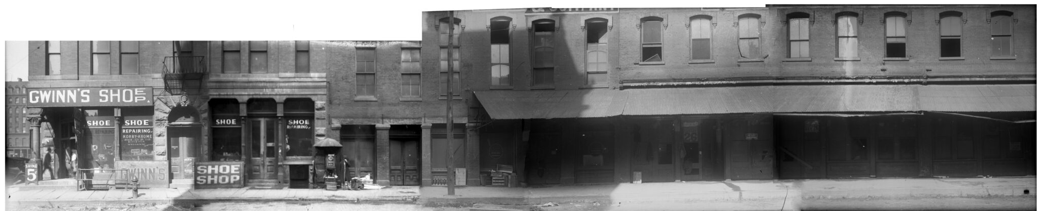
Gwinn’s Shoe Shop, 78 Pryor Street SW on corner of Pryor and Alabama Streets. Sign painted on window reads: “Shoe Repairing” “Korry-Krome Genuine Leather Soles Double Wear.” Sign for “Long Green” sodas on the door to the right. Followed by vacant shops.
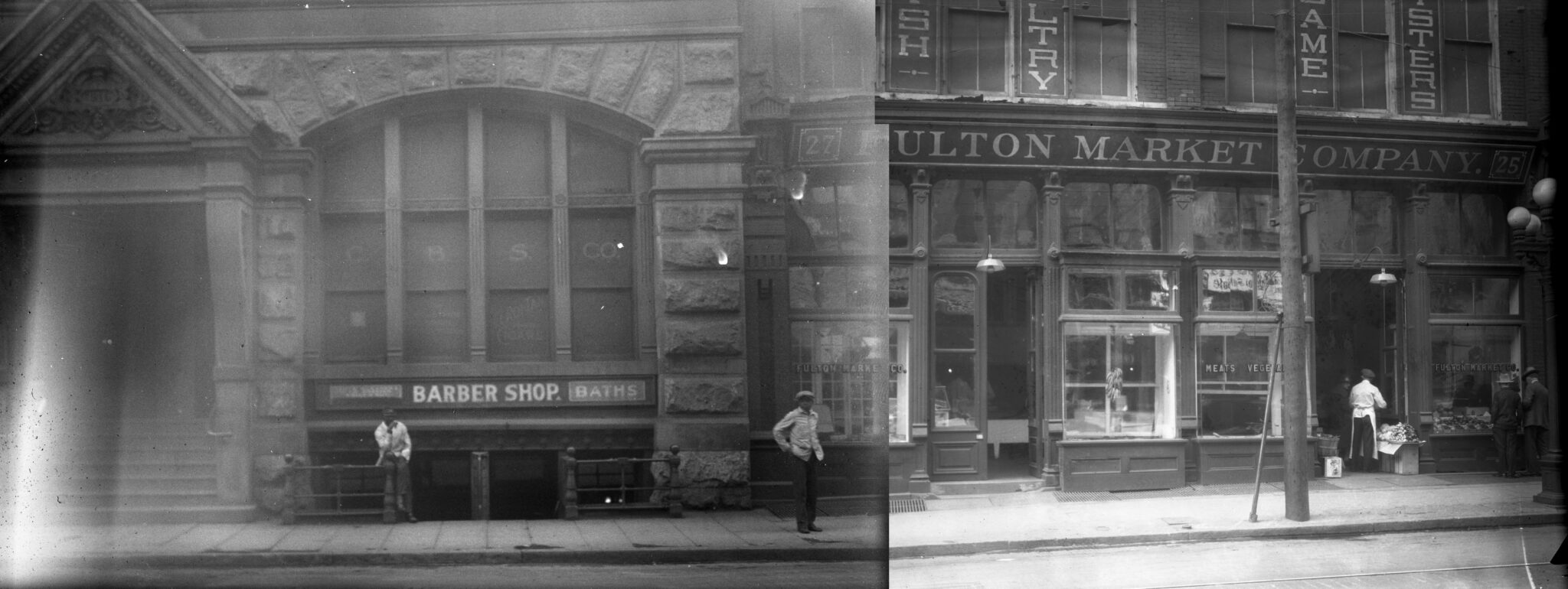
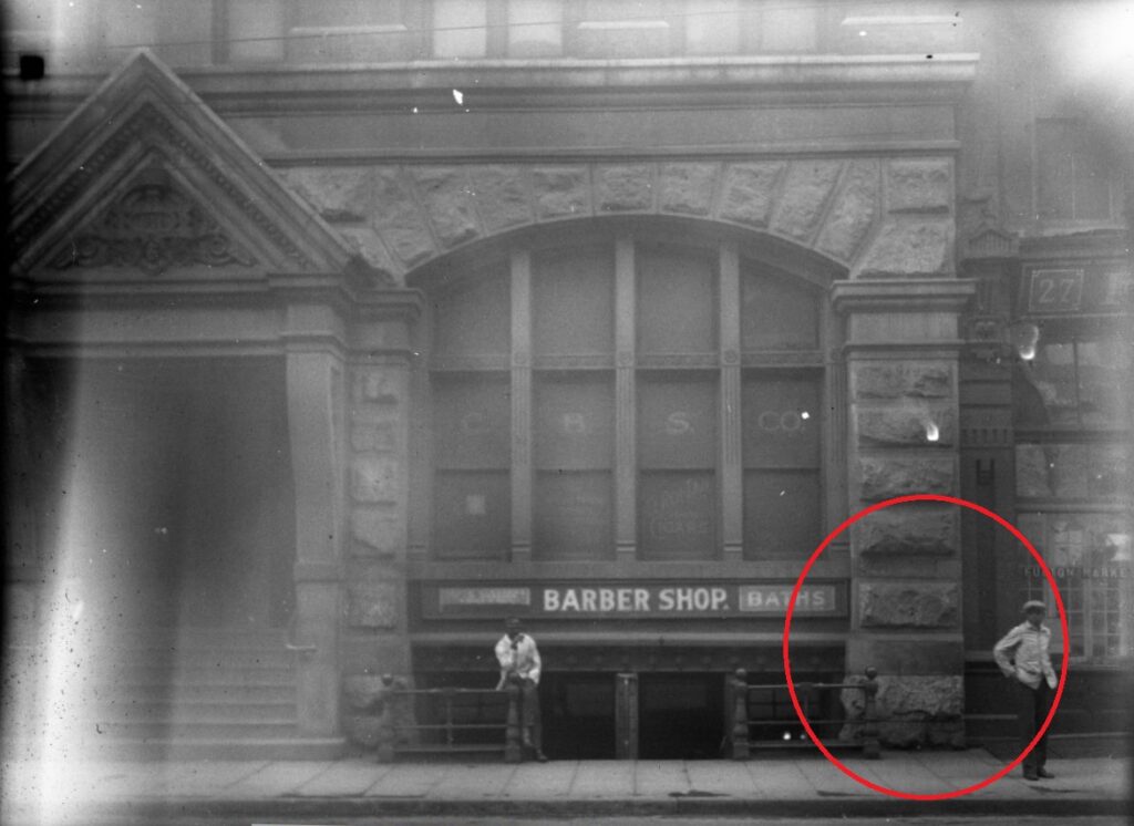
76-80 Alabama Street. Central Building, 76 Alabama Street SW. Bates Barber Shop and Baths, 76 1/2 Alabama Street SW with C.B.S. Company above. Fulton Market Company, 78 – 80 Alabama Street SW.
40-69 East Alabama Street. Western Union, 40 Alabama Street SW Arrow Plating Works, 42 Alabama Street SW. J. B. Almand’s Place, 48 Alabama Street SW. John B. Almand’s Place – Lunches, Cigars, Cigarettes, Bottle Drinks. Sign on window reads: “Moved to 51 1/2 Hunter St.” Adjacent to storefront are advertisements for a Goodrich vs. Sullivan boxing match and Loew’s Grand Theatre. Gus Russell’s storefront. 48 1/2 Alabama St., SW. Atlanta Scale and Fixture Company, 50 – 52 Alabama Street SW. Sign in front of store reads: “Will move to new building 379 Whitehall St. S.W., Jan. 1st”. George Moore Ice Cream Company, Inc., 54 – 56 Alabama Street SW. Gate City Printing Company. Hotel and Restaurant Supply Company, 67 East Alabama Street Sign in window reads: “Will move August 1st to our new building 76 W. Peachtree St.” Atlanta Window Cleaning Company, 69 1/2 East Alabama Street.
25-43/97-119 South Pryor Street. A & W Maloof Billiards, 119 (43) Pryor Street SW. Kiser Law Building, 115 (41) Pryor Street SW, Kiser Building Barbershop and Baths, 113 (39) Pryor Street SW Signs read: “For Rent Adams-Cates Co. 2nd Floor Grant Bldg.” and “For Rent Adair.” Mathews’ Lunch Room, 109 Pryor Street SW. Sign above reads “Drink NuGrape A Flavor You Can’t Forget.” Stove and Furnace Company, 107 Pryor Street SW. Hunter-Adams Company Wholesale Millinery, 105 Pryor Street SW. Sign read: “For Rent Adams-Cates Co. 2nd Floor Grant Bldg.” Palace Billiards Chili Parlor, 103 Pryor Street SW. Sign reads: “Won’t You Hav-A-Tampa Cigar.” Hall Realty Company, 101 Pryor Street SW. Metropolitan Hotel, 99 ½ (27) Pryor Street SW. A & F Stove and Furnace Company, 99 Pryor Street SW. Bennett’s Printing and Stamp Company, 97 Pryor Street SW.
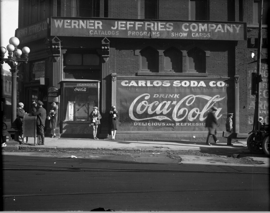
18-40 South Pryor Street. Carlos Soda Company, 70 Alabama Street SW on the corner of Pryor Street. Large Coca-Cola sign on side of building. Above is a sign for Werner Jeffries Company. E. Hanger Inc. Artificial Legs, Arms, and Braces. United Provision Company, 18 – 20 Pryor Street SW. Belcher Heating and Plumbing Company. Torrence’s Lunch Room, 96 Pryor Street SW. The Bankers Health & Life Insurance Company. Sign on Banker’s door reads: “Moved! To 57 S. Forsyth St., This Place For Rent.” J. M. Alexander and Company Hardware, 26 – 28 Pryor Street. Sign Reads: “Removal About March First will be located 14 – 16 Forsyth St. N.W. on Viaduct near Marietta St. J. W. Alexander & Company.” Jones Company Beauty Supplies, 30 Pryor Street SW. Sign in window reads: “Jones Co. Moved to 82-84 Ivy St. Phone WAL.0575.” Avery and Company, 32 – 34 Pryor Street. Hunter’s Garage, 36 – 40 Pryor Street SW. A Crown Gasoline pump is in front of the automobile storage garage.
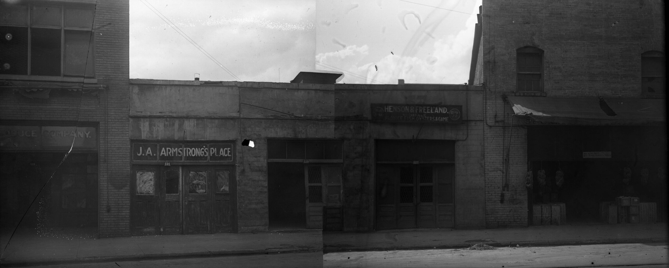
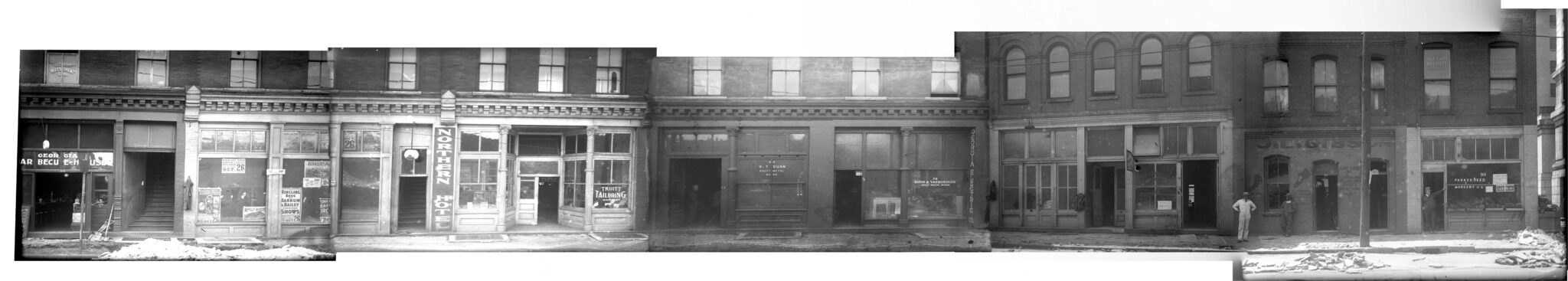
1927. Photographs of the West side of 125-131 Central Avenue. J. A. Armstrong’s Place, 131 Central Avenue SW. Henson and Freeland – Wholesale Produce, Fish, Oysters, and Game, 127 Central Avenue SW. Creety Brothers and Company, 125 Central Avenue SW. Sign reads “We will move to 51 East Hunter Street.”
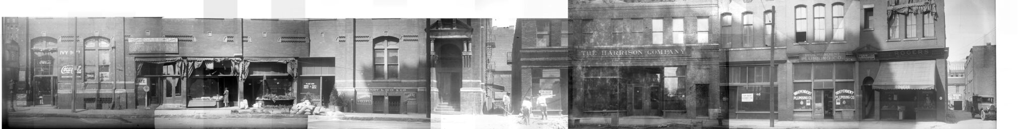
1927. Photographs for the North side of 75-91 East Hunter Street. Martin’s Cafe, Pryor Street SW. Signs read: “Coca-Cola” and “Cigars and Tobaccos, Care, Fruits, Candies, Drink Orange Crush”. Empire Nursery and Seed Company, 89 – 91 Hunter Street SW. Henry Loo and Company – Chinese Groceries and Merchandise, 88 Hunter Street SW. Myron Herzberg Attorney, 87 Hunter Street SW. Myron Herzberg, Roy Lewis, Sigmund W. Teitlebaum, and William W. Tindall had their offices at this address. Harrison Company Publishers and Booksellers, 81 – 83 Hunter Street SW. Letters on building above storefront read: “Camp No. 430 W.O.W. Hall.” Independent Plumbing Company, 77 Hunter Street SW. W.A. and L.S. James Attorneys At Law, 75 Hunter Street. Rogers Grocery, 75 Hunter Street SW. Sign reads: Pure Food Products, Rogers Where Satisfaction is a Certainty, Quality Bread.”
Georgia Barbecue House, 64 Hunter Street SW Window above restaurant reads “Georgia Investment Co.” In window of adjacent building are numerous “Ringling Bros. and Barnum & Bailey” posters for a performance on October 26, 1927. Northern Hotel, 68? Hunter Street SW. Truitt Tailoring Company, 70 Hunter Street SW W. T. Dunn Sheet Metal Work at 72 Hunter Street SW. Dunn and Yarborough Sheet Metal Work, 74 Hunter Street SW. Painted on the brick wall to the right of the window is “Georgia Electric Co.” Blue Produce Co., 76a Hunter Street. Sign reads: Moved to 241 Pryor St. SW J. L. Gibson Shoe Repair, 78 (47) Hunter Street SW. Parker Seed and Nursery Company, 80 (45) Hunter Street SW. Above is Jas [James] E. Garst – R. O. Lovett Attorneys and S. A. Gayarre Notary Public.
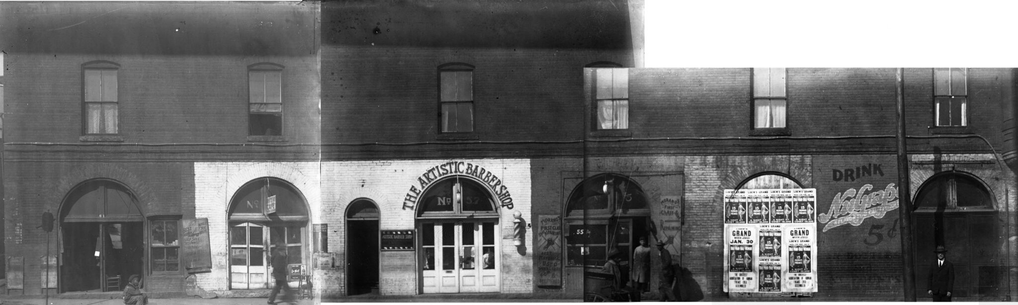
10. Central Avenue West Side 155-61 Central Avenue. Sol Avzaradee’s Shoe Repair, 61 Central Avenue SW. White Way Café, 59 Central Avenue SW. Signs read: “Shoe Repairing While You Wait” and “White Way Café Home Cooking.” J. S. Young’s Artistic Barbershop, 57 Central Avenue SW. Morano’s First Class Shoe Repair, 55 Central Avenue SW. Posters on front of adjacent vacant storefront read: “Loew’s Grand Monday Jan. 30 [1928], Albert and Alberta Half Man-Half Woman with 15 Human Freaks – A Night at Coney Island, The Greatest Aggregation of Human Freaks Ever Assembled.” Painted on adjacent wall: “Drink NuGrape – A Flavor You Can’t Forget – 5 cents in Bottles and at Founts.”
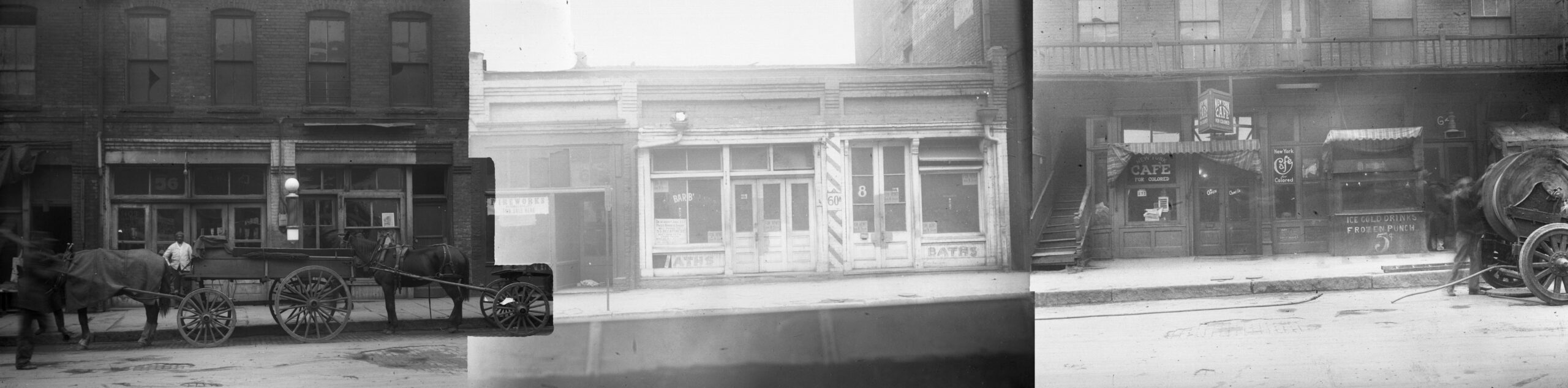
56-60 Central Avenue. Two horse-drawn wagons in front of 56 Central Avenue SW. Solomon E. Pace’s Barber Shop and Baths, 60A Central Avenue SW. Sign in window reads: “On or about June 22 Pace’s Barber Shop will move to 53 Decatur St. next door to the Strand Theatre…”. New York Cafe for Colored, 62 Central Avenue SW.
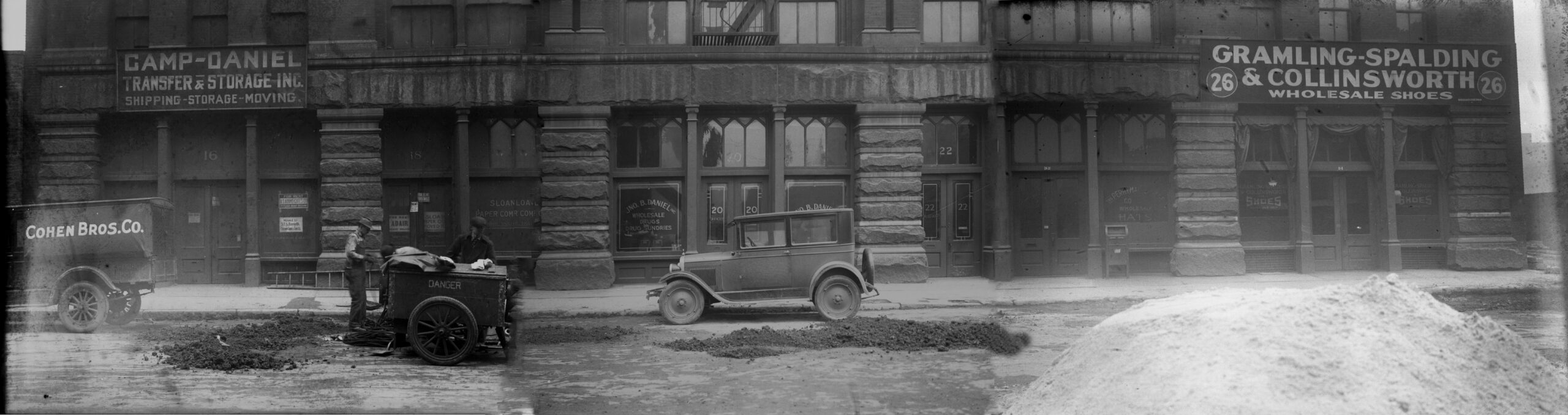
16-26 Central Avenue. Camp-Daniel Transfer and Storage, Inc., 16 Central Avenue SW. Painted on window: “The Crown Cork and Seal Company” and a sign that reads “Moved to 37 S. Forsyth, Crown Cork and Seal Co.” Sloan Paper Company, 18 Central Avenue SW. Wagon with “Danger” and two work men in front of the storefront. Sign that reads “Moved to 483 Whitehall St.” In front of the storefronts are a Cohen Brothers Company truck and men working at a cart labeled “Danger.” Jno. [John] B. Daniel Wholesale Drugs, Inc., 76 -78 Central Avenue. Ford Model A automobile is parked in front. Perryman-Greene Company Wholesale Hats, 82/24 Central Avenue SW. Gramling, Spaulding and Collinsworth Wholesale Shoes, 84/26 Central Avenue SW.
Not much remains…
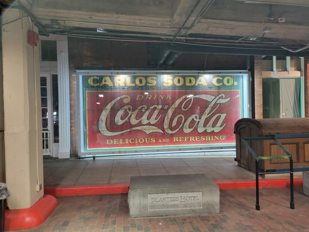
Only a few vestiges of 1927 Atlanta can be found in Underground Atlanta today.
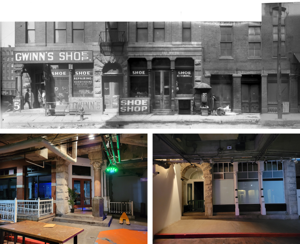
Figure 5. S. Pryor Street at Alabama Street, SE corner, 1927. Atlanta-Fulton Public Library System Glass Plate Negative AFPL002x_003, GSU Library Special Collections & Archives.
Figure 6. The same corner in Underground Atlanta, 2024.
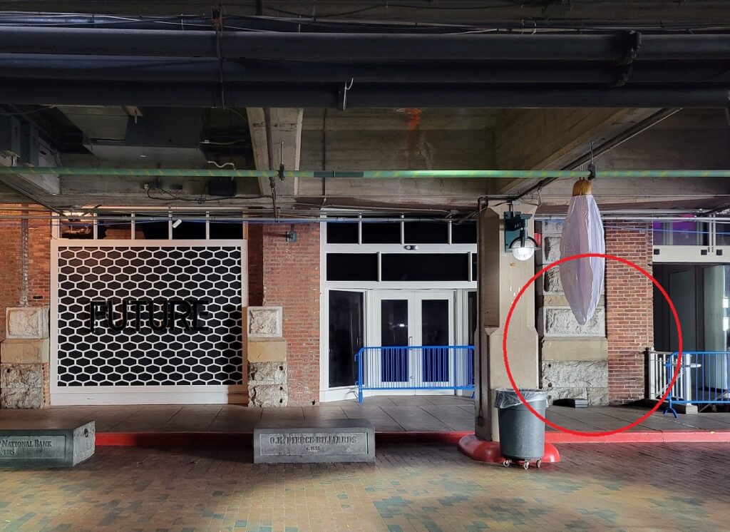
Figure 7. Bates Barber Shop and Baths at 76 1/2 Alabama Street SW, 1927, Atlanta-Fulton Public Library System Glass Plate Negative AFPL001x_006, GSU Library Special Collections & Archives.Figure 8. And what remains today. Contemporary photos by the author.Figure 9. A few architectural elements remain at the northeast corner of Alabama at Pryor Streets, including the ornate column at Gwinn’s Shoe Shop and a portion of the shop’s façade on Alabama St.
Bryan Sinclair is Associate Dean for Public Services at Georgia State University’s main campus library located in downtown Atlanta, where he provides leadership in multiple innovative service areas, including campus outreach, user services, instruction, and growing areas of research data support and data literacy instruction.
Lee, W. H., “Atlanta’s Viaducts in Sight,” The City Builder, August 1927, p. 8.↩
“Work For Viaduct Will Start Today,” The Atlanta Constitution, March 8, 1928, p. 2.↩
“Steam Shovels Prepare Way for Viaducts,” The Atlanta Constitution, March 25, 1928, p. F4.↩